![Furuno SC70 Satellite Compass w/o Cable [SC70]](http://www.bgamarine.com/cdn/shop/files/66667XL.jpg?v=1746219083&width=1500)
Furuno SC70 Satellite Compass w/o Cable [SC70] 26.7 lb
Furuno SC70 Satellite Compass w/o Cable [SC70] está agotado y se enviará tan pronto como vuelva a estar disponible.
Información de cuidado
Información de cuidado
¡Importante! Asegúrese de inspeccionar este artículo antes de realizar su compra. Estamos aquí para ayudarle en cualquier momento. No dude en comunicarse si tiene alguna pregunta o inquietud; ¡estamos más que felices de poder ayudar! Además, ofrecemos opciones de financiación para facilitar su compra.
Entrega y envío
Entrega y envío
Nos complace ofrecer envío gratuito en todos los pedidos dentro de los EE. UU. Sin embargo, para artículos de gran tamaño, es posible que se aplique una tarifa de envío adicional. Nos esforzamos por garantizar la entrega oportuna y segura de sus productos, asociándonos con los mejores servicios de envío. Para cualquier consulta sobre nuestra política de envío, no dude en ponerse en contacto con nuestro equipo de atención al cliente. ¡Gracias por elegir BGA Marine!

Furuno SC70 Satellite Compass w/o Cable [SC70]

Furuno SC70 Satellite Compass w/o Cable [SC70] está agotado y se enviará tan pronto como vuelva a estar disponible.
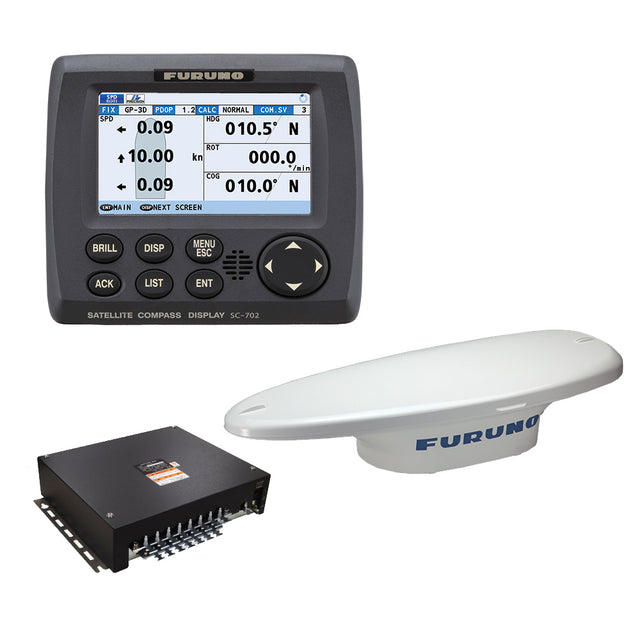
SC70 Satellite Compass w/o Cable
The SC70 is the latest satellite compass built on FURUNO’s commercial-grade technology platform. These satellite compasses prove their value by increasing the accuracy of other devices, such as Radar, ARPA, Scanning Sonar, Current Indicator, Chart Plotter, ECDIS and Autopilots. They provide a highly accurate heading input to these other technologies by utilizing the very latest GNSS (Global Navigation Satellite System). This satellite system is comprised of GPS, Galileo and GLONASS to ensure the highest precision and a continuous coverage.
The SC70 provides a variety of data, including GPS Positioning, SOG (Speed Over Ground), COG (Course Over Ground), ROT (Rate Of Turn) and 3-axis speed (bow, stern and longitudinal). All of these data assist with critical maneuvers, such as berthing. The compasses is maintenance free - a great asset for any vessel.
Consists Of:
- SC701 - Junction box for SC70/SC130
- SC702 - Display unit for SC70/SC130
- SC703 - ANT 2GPS/ANG/ACCEL/MGNT SNSR
Note: The SC70 and SC130 are sold without an antenna cable.
Standard Features:
- Provides highly accurate heading data of 0.4° for autopilot, Radar, ARPA, Scanning Sonar, Current Indicator, Chart Plotter, ECDIS and Autopilots
- Ideal for small to medium boats requiring highly accurate heading
- Utilizes GNSS such as GPS, Galileo and GLONASS for high Precision
- SBAS compatible (EGNOS,WAAS,MSAS)
- Provide precise data for SOG, COG, ROT and L/L
- Eliminating the problem of not having enough satellites at hand by using multiple types of satellites
- Speed on 3 axis (bow, stern and longitudinal) for safe navigating and berthing
- IMO Type-approved as THD, GPS and ROTI. Complying with the IEC, ISO requirements
- Easily integrated into the existing shipboard network via Ethernet
- Rapid follow-up rate 40°/s (twice the IMO high speed craft requirement, 20°/s)
- Maintenance free and no recurring cost as there are no mechanical parts
- Super short starting time - 90 seconds
- Once the power is on, it takes about 90 seconds to start (the starting time will slightly differ depending on the equipment location)
- Easy to retrofit by using existing antenna cabling for SC-50/55/60/110/120. (The LAN_CNV option kit is necessary)
- Precision pitch/roll data in Analog and Digital formats for vessel stabilization, Sonar, etc.
Owner's Manual (pdf)
Brochure (pdf)
Pago y seguridad
Métodos de pago
Su información de pago se procesa de forma segura. No almacenamos datos de tarjetas de crédito ni tenemos acceso a la información de su tarjeta de crédito.